Track drought by watching the ground move.
The United States Geodetic Drought Index (US‑GDI) uses daily GPS‑measured surface deformation to infer total water storage changes—bringing a physics‑based view to hydrologic drought monitoring across the nation.
The Nevada Geodetic Laboratory, where we obtain our GPS observations, is currently in transition from IGS14 to IGS20 solutions. Until NGL completes this transition, we will update our products whenever new positions are available. Once the transition is complete (expected ~Fall 2025), US‑GDI solutions will be evaluated daily, with rapid solution latency of under 48 hours.
Current study period: January 2008 – August 2025
Expected full study period: January 2008 – Present
Hydrogeodesy for Drought Monitoring!
GPS can do more than navigate—it can track water. As water moves through the environment, whether as rain, snow, groundwater, or soil moisture, it adds weight to the land. This shifting weight causes the Earth’s surface to rise or sink slightly. GPS stations are sensitive enough to detect these tiny movements.
The field of hydrogeodesy uses these signals to evaluate changes in water storage across entire regions. Unlike traditional methods that rely on point source sensors in rivers, lakes, or aquifers, hydrogeodesy can detect these changes in near real time, even in places with little or no direct monitoring.
This powerful tool gives decision-makers a clearer picture of water availability, helping advance policies for drought response and water management.
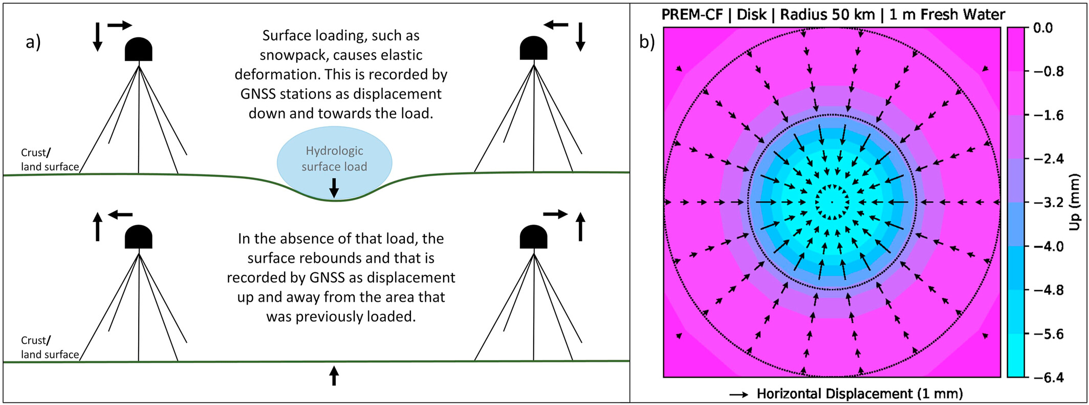
A thorough review of hydrogeodesy can be found in White et al., 2022. The following is their Figure 1.
Caption: Conceptual model from White et al. (2022) showing the elastic response of the Earth's surface to hydrologic loading.
Not all droughts are created equal.
A meteorologic drought happens when there’s less rain or snow than usual over a period of time. It tells us how dry the weather is, but not necessarily how dry the land or rivers are.
A hydrologic drought, on the other hand, is about the water we rely on in streams, groundwater, and moisture in the soil. These water shortages often show up weeks or months after the skies dry out, and they can stick around long after rainfall returns to normal.
Meteorologic drought is easier to track with weather data. But hydrologic drought is what impacts farms, drinking water, and ecosystems the most, and it's much harder to measure. That’s where hydrogeodesy becomes especially valuable: it helps us monitor changes in water storage, even in places without direct monitoring.
A new way to see drought — through the ground itself.
The U.S. Geodetic Drought Index (US‑GDI) takes a unique approach to tracking drought. Instead of measuring rainfall or temperature, it looks at how the Earth’s surface physically moves in response to changing water storage.
Using daily measurements from a nationwide network of GPS stations, the US‑GDI uses estimated hydrologic loads calculated from tiny movements, just millimeters in size, that reflect how much water is being added or lost on the surface or underground. These subtle changes are then compared to typical seasonal patterns to produce a drought index grounded in the physics of land deformation.
This approach offers several advantages. It works even in remote areas with limited water monitoring infrastructure. It can highlight the lingering effects of long-term droughts, catch quick rebounds after big storms, and reveal early warning signs of groundwater loss or recovery.
Importantly, the US‑GDI doesn’t replace traditional drought tools, it adds to them. By providing an independent view of how water is moving through the Earth, it strengthens our ability to monitor, respond to, and plan for water-related risks.
For more details, see Young et al., 2024.
Turning Ground Movements into Actionable Insight
For decision-makers, understanding where, when, and how severely drought is affecting water resources is essential, but traditional tools can fall short, especially when it comes to what's happening underground.
- Groundwater management: US‑GDI data can help identify areas experiencing unseen groundwater depletion, guiding sustainable extraction limits and recharge planning.
- Drought preparedness: Because it responds to total water storage, not just surface water, the index can offer early warning signs of drought conditions before traditional indicators detect them.
- Infrastructure planning: Long-term trends in land deformation can inform where investments in water infrastructure, such as storage or conveyance systems, are most needed.
- Disaster response and recovery: In the wake of storms or droughts, GPS-based monitoring can track how quickly the land and water systems are rebounding, helping to allocate resources efficiently.
By incorporating geodetic data into drought monitoring frameworks, agencies and policymakers gain a more complete picture of water availability, one that captures both visible and invisible components of the hydrologic cycle. This leads to more resilient planning, more equitable resource distribution, and better outcomes for people and ecosystems alike.